Terraces, Water, and the Shape of a Rice Landscape
Read a rice landscape through terraces, channels, and field conditions, while separating visible clues from local farming practices and food traditions.
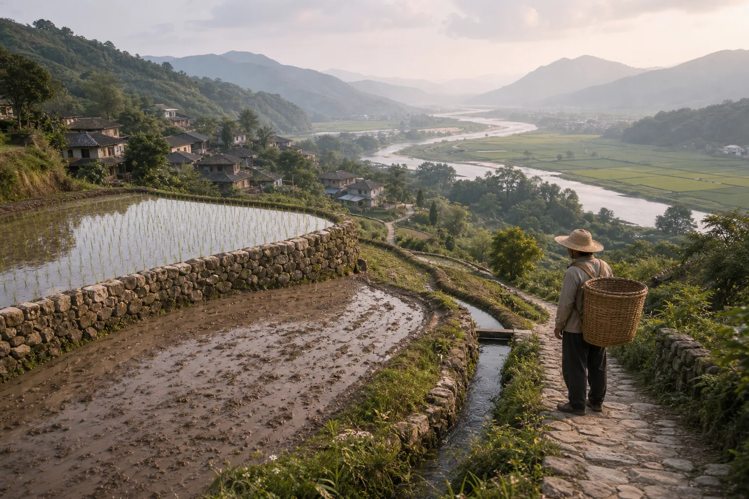
From a public path above a rice-growing valley, you might see stone-edged terraces, a stream-side channel, and plots at different stages of cultivation. A rice landscape is easier to understand when you read its terrain and water together, then ask how those features connect to local foodways.
Begin with what is visible: whether fields climb a slope or spread beside a river, where channels appear to enter or leave plots, and how paths connect farms to homes or markets. These observations can guide good questions, but they cannot establish local rules or explain how a particular rice variety is grown, processed, or cooked.
Read the terrain
On sloping ground, terraces create cultivated surfaces across the hillside. Their edges may be made of earth, stone, or a combination of materials. A terrace’s appearance can suggest how the land has been shaped, but it does not reveal who built or maintains it.
Flatter fields may lie near a river or across a plain. Bunds, drains, and channels can mark the movement of water, though their purposes depend on the site and season. A field beside a river is not automatically a floodplain; local topography and water patterns matter.
Think of a channel like a path with junctions: tracing its visible route shows connections, but not who may use it or when. Stay on public paths, keep a respectful distance, and do not cross banks or enter planted fields.
Trace rice field water
Water may come from rainfall, a stream, a spring, a reservoir, or several sources. Channels, gates, openings, and temporary barriers may guide it toward or away from fields. From a permitted viewpoint, note where a channel begins, which plots it passes, and where it continues. Never touch a gate or barrier to test what it does.
Neighboring plots may look different: one may hold water while another appears muddy, green, or comparatively dry. Those contrasts could reflect cultivation timing, local practice, soil, or water availability. Appearance alone cannot identify the cause.
Water arrangements are local. Farmers may coordinate channel upkeep or water distribution, but a visible channel does not tell a visitor how responsibilities are assigned. Ask a farmer or local guide how the system works, and keep that explanation tied to the place where it was given.
Follow work and foodways
Paths link homes, plots, channels, and places where tools or harvests move. A crossing over a watercourse can show how people get around it; a maintained bank can show that someone attends to it. Neither feature reveals the full labor arrangement, which may involve households, neighbors, paid workers, or other groups.
Rice farming reflects terrain, water, labor, and local choices. A landscape may show machinery, handwork, or both, but it cannot tell you by itself which grain is being grown or how it will be prepared. Seed selection, processing, storage, and cooking all shape the food that reaches a table.
To connect a rice product with its landscape, ask where it was grown and how it was processed. A place name on a sign or package may identify a region without answering both questions. At a market, a seller may be able to explain which local distinctions matter to buyers and cooks.
Compare places carefully
For a grounded comparison, record whether a field lies on a slope or near a river, whether a channel is visibly connected to it, and how paths link the plots. Then ask a knowledgeable resident, seller, or guide which distinctions people in that place actually make. Similar-looking fields need not produce rice with the same qualities or culinary uses.
Say you are on a public path above a hillside village. For this invented example, your starting notes are three visible features: a stone-edged upper plot holding water, a lower plot that looks muddy, and a narrow channel that continues downhill. You want to describe the scene without guessing why the plots differ.
- Write down the terrain first: both plots are on a slope, and the upper plot has a visible stone edge. The decision is to describe the upper field as terraced only if its cultivated surface is clearly shaped across the slope; otherwise, record the stone edge without assigning it a function.
- Trace the channel from the public path. You can see it continue downhill, but not where it begins or ends. The decision is to record the visible direction and leave its source and destination unknown.
- Compare the field conditions: the upper plot holds water and the lower plot looks muddy. The decision is to describe that contrast, not to claim that one plot receives more water or is at a different stage.
- Ask a local guide whether the plots are at different stages or follow different water arrangements. If the guide explains one plot’s condition, attribute the explanation to that place; if the answer does not settle the question, leave the cause open.
The resulting account is specific but cautious: two plots sit at different points on a slope, a channel continues downhill, and their visible conditions differ. You can then ask how those fields fit local cultivation and foodways rather than treating the view as a complete account of rice production.
What can a rice landscape tell you?
How does a terrace differ from a floodplain?
A terrace is a cultivated surface shaped or supported on sloping ground. A floodplain is relatively flat land beside a river that may be affected by flooding; local conditions determine how it is farmed.
Why might one rice field be wet and another dry?
Plots may be at different points in cultivation or follow different local water practices. Ask someone familiar with the site before assigning a cause to what you see.
How can you observe field water safely?
Watch channels from public paths and note where they appear to enter or leave plots. Do not cross banks, enter farmland, or adjust gates; ask a local farmer or guide about details that are not visible.
What does a shared channel reveal about local practice?
It shows a connection between places, but not how access, upkeep, or decisions are organized. Ask locally about those arrangements instead of treating the channel as proof of a shared custom.
Observe without disturbing
- Check the terrain: If the ground rises in cultivated steps, describe it as terraced; if it lies beside a river, note that position without calling it a floodplain unless local conditions support that description.
- Check the channel route: If you can see a channel enter or leave a field from a public path, record that connection; if you cannot, leave its source or destination open and ask a local guide.
- Check neighboring plots: If their visible conditions differ, describe the contrast; if no local explanation is available, do not assign a cause.
- Check your access: If the path is public and open, remain on it; if access is unclear or the route crosses farmland, choose another viewpoint and ask permission before proceeding.
- Check gates and barriers: If one is visible, note its position without moving it; if its function is unclear, ask someone familiar with the system rather than guessing.
- Check the scope of local explanations: If a farmer or guide describes a specific practice, attribute it to that person or place; if the explanation does not cover wider customs, do not generalize it to a region.
A rice landscape offers useful clues about terrain, water, and the work that connects fields to food. Use the phrase rice landscape as a starting point for observation: describe what you can see, ask who can explain what you cannot, and keep local food traditions attached to the people and places that describe them.
Keep exploring
The Orchard Between Two Kitchens
Trace how apples take on different roles across neighboring food traditions, and learn to choose a…

A Market Stall Has Its Own Geography
Market stall geography helps you trace one ingredient from its stated source through the market, so…